
Our Solution: FIT – The Digital Platform for Fisheries Control
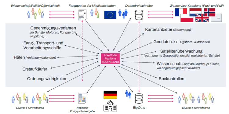
Scopeland Technology developed the Fisheries Information System (FIT), an integrated low-code solution that digitizes and interconnects all specialized processes involved in fisheries enforcement.
FIT is the BLE’s central control and information system: It manages fishing vessels, permits, quotas, catch data, and geographic information in a unified digital environment. The platform combines high technical expertise, data intelligence, and user-friendliness—thus enabling a fully digitized overview of fisheries management.
More than 58 specialized modules and approximately 2 million lines of code, 25% of which involve geodata, were generated automatically at a rate of over 99% using SCOPELAND low-code technology.
This exceptional level of automation significantly shortened development times and ensures maximum flexibility for future requirements.
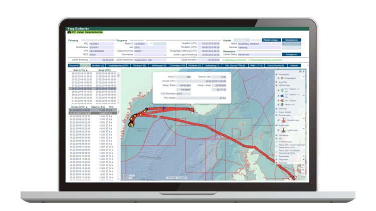
A particular highlight is the embedded GIS approach: geodata is fully integrated into business processes. Maps, fishing areas, and maritime boundaries can be analyzed and directly incorporated into technical decisions—a first in European government IT.

99,2%
automatically generated

2 million
lines of code

58
Specialized modules

25%
Geodata Reference
All in one platform
With FIT, the BLE now has, for the first time, a fully digital, networked system that centrally manages all fisheries control tasks.
Whether it’s data exchange with EU systems, quota management, or mobile inspection operations—all functions work seamlessly together, creating a new level of efficiency, transparency, and security.
Highlights & Features
- Central data platform with interfaces to electronic logbooks, EU systems, sales data, and national specialized applications
- Automated cross-checks and plausibility checks for secure, valid decision-making
- Digitized fishing vessel registry with integrated application and approval processes
- Seamlessly embedded GIS functionality for mapping fishing trips, fishing grounds, and maritime boundaries
- Offline-capable inspection software for use on the high seas—robust and field-tested
- Specialized applications for fish species, fishing gear, wind farms, quotas, maritime boundaries, and much mor
Project success
The FIT project is now regarded as a technological milestone in the digitization of public administration:
- Quick deployment, despite changing EU regulations
- High flexibility through low-code development in response to new legal requirements
- High usability, developed in close collaboration with business users
- Transparent management and control of all fishing data in real time
- A model for Europe – numerous public authorities are adopting the FIT system
What Others Say About FIT (in German)
Contact us
Would you like to learn more about how to integrate GIS data into your business application?